Public Notice – 2027-2036 Ten Year Plan (TYP)
November 13, 2024
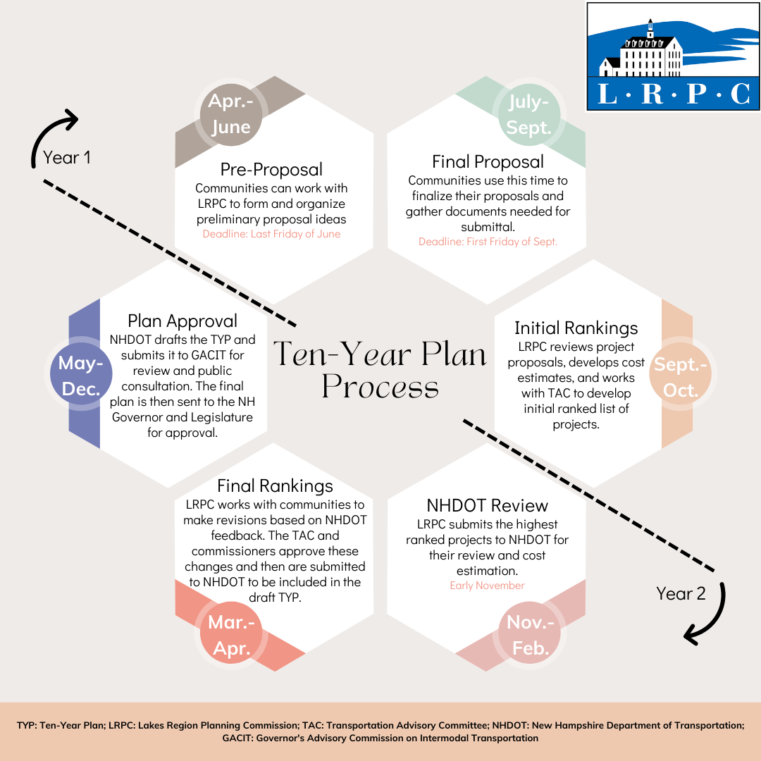
The Lakes Region Planning Commission’s Transportation Advisory Committee (TAC) recently completed review of the submitted Ten Year Plan projects. In that process, members of the TAC evaluated the submitted Plymouth project scope against the criteria suggested by the State DOT and adopted by the TAC, and included weighting by regional importance. This process is referred to as “Initial Ranking” in the DOT’s Ten-Year Plan process.
The next steps in the process are for the submitted project proposal, along with the weighted criteria scores, to be submitted to NHDOT for their review. This includes vetting of project scope and verification of cost estimates across all projects submitted throughout the state. During this process from November – February, the NHDOT will develop their own rankings, comment on each project, and draft the 2027-2036 New Hampshire Ten-Year Plan. After the draft is issued, the Governor’s Advisory Commission on Intermodal Transportation (GACIT), which is made up of the five Executive Councilors and the Commissioner of the New Hampshire Department of Transportation, will hold a number of public hearings to solicit public input on the projects and priorities submitted to the TYP.
NH SADES

University of New Hampshire’s Statewide Asset Data Exchange System (SADES) provides a common set of collection and training standards. This ensures that data collected throughout the state is comparable and assessed uniformly.
Local Assistance
USDOT Grants and Technical Assistance Navigator Tool
The US Department of Transportation (USDOT) has launched the DOT Navigator, a new online resource designed to help communities identify federal grant and technical assistance opportunities. The DOT Navigator tool includes:
- A NEW rural eligibility mapping tool, helping potential applicants to verify whether their region would qualify as urban or rural for various different USDOT programs
- A searchable database of technical assistance opportunities
- A variety of grant application resources
Several transportation grant programs are currently open relating to safety, tribal transit, ferry service, and more.
Aviation Assistance
- Possible Funding Opportunities:
- Transportation Study Support
- Past Projects:
- NH Route 16 Corridor Safety Assessment (2015)
- NH Route 140 Corridor Study (2013)
- NH Route 28 Corridor Study (2009)
- NH Route 25 Corridor Study – Center Harbor and Moultonborough (2008)
- NH Route 104 Access Management Study – New Hampton and Meredith (2007)
- US Route 3 Corridor Study, Franklin and Boscawen (2024)
Road Surface Management Systems (RSMS)
Public Transportation